Draws an image overlay draped onto the terrain.
The Href specifies the image to be used as the overlay.
This file can be on a local file system or on a web server. If this element is
omitted or contains no Href, a rectangle is drawn using the color and Lat
Lon Box bounds defined by the Ground Overlay.
When Edit is 'on'  you can move, rotate and resize the overlay.
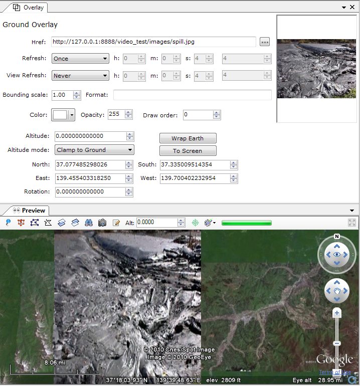
| Href: | The image associated with the Overlay. This location can be either a local file or on the Internet. If this element is omitted or contains no path, a rectangle is drawn using the color and size defined by the Ground or Screen Overlay. |
| Refresh: |
Specifies to use a time-based refresh mode. |
| View Refresh: |
Specifies how the link is refreshed when the viewport changes. |
| Bounding Scale: | Scales the Bounding Box parameters before sending them to the server. A value less than 1 specifies to use less than the full view (screen). A value greater than 1 specifies to fetch an area that extends beyond the edges of the current view. |
| Format: |
Specifies the format of the query string that is appended to the Link's Href before the file is fetched. (If the Href specifies a local file, this element is ignored) |
|
Color: |
Opens a Color dialog. The color white is equivalent to removing the color, that is, the icon will not have its color altered. |
|
Opacity: |
A ratio indicating how opaque the icon is. The ratio is between 0 for transparent and 100 for fully opaque. |
|
Draw order: |
This element defines the stacking order for the images in overlapping overlays. Overlays with higher draw order values are drawn on top of overlays with lower draw order values. |
|
Altitude: |
Specifies the distance above the earth's surface, in meters, and is interpreted according to Altitude mode below. |
|
Altitude mode: |
Specifies how the Altitude is interpreted. Possible values:
|
Specifies where the top, bottom, right, and left sides of a bounding box for the Ground Overlay are aligned.
|
North: |
Specifies the latitude of the north edge of the bounding box, in decimal degrees from 0 to ±90. |
|
South: |
Specifies the latitude of the south edge of the bounding box, in decimal degrees from 0 to ±90. |
|
East: |
Specifies the longitude of the east edge of the bounding box, in decimal degrees from 0 to ±180. (For overlays that overlap the meridian of 180° longitude, values can extend beyond that range.) |
|
West: |
Specifies the longitude of the west edge of the bounding box, in decimal degrees from 0 to ±180. (For overlays that overlap the meridian of 180° longitude, values can extend beyond that range.) |
|
Rotation: |
Specifies a rotation of the overlay about its center, in degrees. Values can be ±180. The default is 0 (north). Rotations are specified in a counterclockwise direction. |
Wrap Earth Button
Will attempt to wrap the overlay around the whole earth.
Wrap To Screen Button
Will wrap to the earth's client area.
Edit Handles Example
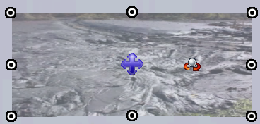
These handles provide but a rudimentary way of resizing and rotating but moving the overlay behaves properly.
 |
Resize. |
 |
Move. |
 |
Rotate. Double-click to reset the rotation to 0. |